Geographic Information Systems (GIS) are powerful tools that integrate, analyze, and visualize spatial data to support decision-making across diverse fields. GIS enables users to map, manage, and interpret data by combining geographic information with other datasets, providing insights into patterns, relationships, and trends. Widely used in urban planning, environmental monitoring, transportation, and public health, GIS empowers organizations to solve complex problems, optimize resource allocation, and plan effectively. From disaster management to precision agriculture, GIS fosters data-driven solutions that bridge the gap between location and information.
Geographic Information Systems
Geographic Information Systems


Remote sensing services includes in the following verticals :
Remote Sensing involves acquiring information about the Earth's surface and atmosphere without direct contact, using sensors mounted on satellites, drones, or aircraft. This technology captures data across a range of wavelengths, including visible, infrared, and microwave, to analyze land use, vegetation health, weather patterns, and more. Remote sensing is indispensable in monitoring environmental changes, assessing natural disasters, and supporting urban and agricultural planning. With its ability to cover vast areas efficiently and deliver consistent, multi-temporal data, remote sensing is a cornerstone of modern geospatial analysis.
We provided are:
- Utility Mapping
- Cadastral Mapping
- Land Use/ Land Cover
- Topographic Mapping
- Parcel Mapping
- Remote Sensing
Mining Mapping
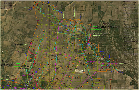
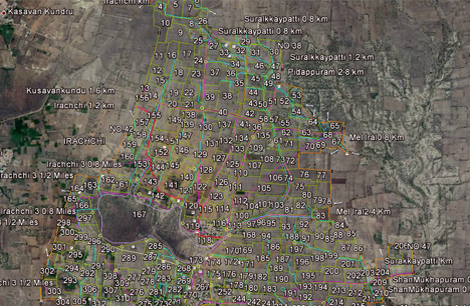
Cadastral Mapping
Classification Supervised and Unsupervised
Change Detection
Slope Aspect Analysis
Land Cover Classification
Coastal Ecosystem Management
Forestry Mapping
Agriculture Mapping
Mining Mapping involves the creation of detailed maps that track geological features, mineral deposits, and excavation areas in mining operations. This type of mapping is essential for resource management, site planning, and ensuring safety. It typically combines remote sensing, LiDAR, and GIS to provide accurate data on the terrain, depths, and boundaries of mineral resources, facilitating efficient extraction and environmental monitoring.
Cadastral Mapping is the process of creating detailed maps that define land ownership, boundaries, and property rights. It plays a crucial role in land administration, helping governments and private entities manage property transactions, zoning, taxation, and disputes. Cadastral maps provide precise information on parcel boundaries, land use, and infrastructure, supporting legal, environmental, and developmental decisions.
Classification (Supervised and Unsupervised) refers to methods used in remote sensing and GIS to categorize land cover or other features in an image or dataset. Supervised classification involves training the model with known data, teaching it to recognize patterns and classify new data accordingly. Unsupervised classification, on the other hand, identifies natural groupings or clusters within the data without prior knowledge, helping to explore unknown patterns. Both methods are vital for land use mapping, environmental monitoring, and resource management.
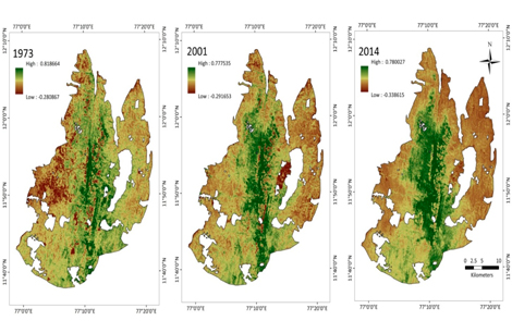
Change Detection refers to the process of identifying differences in the state of an object or phenomenon by comparing datasets over time. This technique is invaluable in monitoring environmental changes, urban expansion, deforestation, or damage from natural disasters. By detecting changes in topography, vegetation, or infrastructure, change detection supports timely decision-making and adaptive management.
Slope Aspect Analysis is a GIS technique used to analyze the steepness and orientation of terrain. The slope indicates the gradient or steepness of the land surface, while the aspect describes its orientation relative to the cardinal directions. This analysis is crucial for applications in agriculture, forestry, hydrology, and urban planning, as it helps to understand water drainage, sun exposure, and the suitability of land for various uses.
Land Cover Classification categorizes the Earth's surface based on the natural or artificial materials present, such as forests, grasslands, water bodies, urban areas, and more. It provides essential information for environmental management, urban planning, and natural resource management. Using satellite imagery and remote sensing data, land cover classification helps to track land use changes, assess ecosystem health, and plan conservation efforts.
Coastal Ecosystem Management involves the monitoring and protection of coastal environments, including beaches, wetlands, mangroves, and coral reefs. This field integrates remote sensing, GIS, and environmental science to study changes in coastal ecosystems due to human activity, sea-level rise, and climate change. Effective coastal ecosystem management is essential for preserving biodiversity, managing natural resources, and protecting coastal communities from environmental hazards.
Forestry Mapping is the practice of using satellite imagery, LiDAR, and GIS to assess and monitor forests' health, density, species composition, and growth. These maps are critical for sustainable forestry management, biodiversity conservation, and tracking deforestation. Forestry mapping provides insights into carbon storage, forest regeneration, and the impact of logging or natural disasters on forested areas.
Agriculture Mapping uses remote sensing and GIS technologies to analyze crop health, soil quality, irrigation systems, and land use patterns. Agriculture mapping supports precision farming by providing real-time data on field conditions, helping farmers optimize yields, reduce costs, and minimize environmental impact. It also aids in monitoring seasonal variations, assessing drought or flood risks, and planning crop rotation strategies to maintain soil health.
Back to top