The forest industry has utilized remote sensing since the earliest days of aerial photogrammetry. Traditionally this has involved using stereoscopes and manual interpretation to extract three-dimensional information about the vertical forest structure. Often this information was not reliable, adequate, or timely enough to make fully informed decisions. With the advent of laser scanning, natural resource managers are experiencing and unprecedented shift in the tools at their disposal. Geo AdithyA's active LiDAR systems can now provide a direct 3-D measurement of vegetation and terrain surfaces with accuracy that was once only imagined.
Forestry Management
Forestry Management
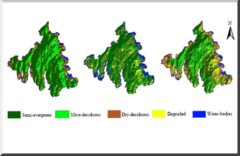
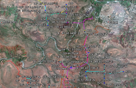
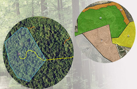
Image Tree a division of Geo AdithyA and its patented Forest Sense process combine high-resolution Color Infrared (CIR) imagery, Light Detection and Ranging (LiDAR) and advanced biometrics to revolutionize your forest inventory accuracy while reducing your costs. This information in combination with client silviculture information forms the basis for 3-D stratification and field sample design. Ground data are then combined with biometric equations to produce a reliable forest inventory. Literally, hundreds of variables can be extracted, analyzed, and measured. As a result, you are able to leverage this data for improved forest inventories and make more precise silviculture decisions. The Image Tree process has also been approved for use by the Climate Action Reserve for carbon sequestration and has been shown to reduce required field sampling by up to 50% while improving the precision of the estimate. Faster, cheaper, better inventories are now possible for all of your resource management needs.
Key Geospatial Solutions
| Solution | Description |
|---|---|
| Forest Inventory & Mapping | Using GIS and remote sensing data to map forest areas, tree density, and species composition. |
| Deforestation Monitoring | Utilizing satellite imagery and change detection techniques to track and analyze deforestation and degradation over time. |
| Forest Health Monitoring | Leveraging remote sensing data to assess forest health and detect pests, diseases, or environmental stressors. |
| Biodiversity & Habitat Mapping | Mapping critical habitats to support wildlife conservation efforts and sustainable forestry management. |
Technological Advancements
-
LiDAR for Precision
Achieve unprecedented accuracy in measuring forest structures, from canopy to terrain. Generate direct 3D data for better visualization and analysis of forest ecosystems.
-
Color Infrared (CIR) Imagery
Capture high-resolution imagery to assess vegetation health and identify stressors. Support forestry operations with detailed spectral data for accurate mapping.
-
Forest Sense Technology
GeoSpatial World’s patented Forest Sense combines multiple geospatial tools to deliver integrated solutions. Minimize costs and maximize accuracy in forestry management.
Back to top